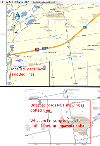
I have been working at this for hours and have tried numerous settings without any luck.
With the OpenStreetMap from OpenMapChest unpaved roads show as dotted lines. When I use the .osm.pbf download from geofabrik.de for Ontario with mkgmap the gmap it produces doesn’t show the unpaved roads as dotted lines.
I’ve gone through the documentation and wiki for mkgmap used the sample files without any success. I did find where it said highway=track and have made sure that is in there.
Here is my batch file.
java.exe -Xmx4000m -jar mkgmap\mkgmap.jar -c mkgmap/examples/sample.cfg mkgmap/examples/typ-files/sameOrder.txt --style-file=mkgmap/examples/styles/default --output-dir=map --country-name="Ontario" --country-abbr=ON --family-id=1956 --family-name="OSM Ontario 0-06-2023" --series-name="OSM Ontario 0-06-2023" --area-name="OSM Ontario 0-06-2023" --product-id=1 --index --bounds=bounds-latest.zip --route --housenumbers --process-destination --process-exits --gmapsupp -c split\template.args split\*.osm.pbf
I’m wondering what I’m doing wrong or missing?
1 post - 1 participant
Ce sujet de discussion accompagne la publication sur https://community.openstreetmap.org/t/how-to-get-mkgmap-to-show-unpaved-roads-as-dotted-lines-in-basecamp/9541
